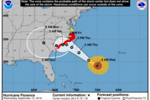
States brace for huge hurricane Florence
As Hurricane Florence approaches the East Coast of the nation it is rapidly getting stronger. Forecaster predictions are dire and the three states in its path are bracing for the worst including historic flooding with up to 45 inches of rain.
It will literally be unlike anything the nation’s eastern seaboard has seen in recorded history.
Up and down the coast communities are evacuating hospitals that have been ordered to complete the transportation of patients by Thursday afternoon. In addition, residents are being told that shelters in many coastal counties will not be open because they are not strong enough to survive the wind or historic storm surge that is expected.
 The storm will likely hit the East Coast as a powerful Category 4 or possibly Category 5 hurricane. So big is the storm that, once moving inland, its outer precipitation bands will reach all the way to southeastern Missouri according to television station KCTV5 weather in Kansas City. A new track map released Wednesday showed the storm moving westward as a powerful tropical depression then turning north over Nashville before moving into the heart of Indiana and Ohio. At the same time, another un-named storm is forming in the Gulp and is expected to make landfall along the Gulf Coast early next week.
“The most hideous aspect of this may be that the track is hitting perpendicular. This is not an arcing storm, this is coming right in at 90 degrees, and those are the worst storms as far as keeping their intensity,” explains WeatherBELL Meteorologist Joe Bastardi.
“We do know that we’re in the bulls-eye,” said North Carolina Gov. Roy Cooper. “North Carolina is taking Hurricane Florence seriously and you should too. Get ready now.”
Residents along the coast in North Carolina, but also South Carolina and Virginia have already been issued mandatory evacuation orders.
The most sweeping orders come from South Carolina, where the entire coastline was given until Noon Tuesday to leave as state troopers made all Interstates and other major freeways only westbound. For hours, trooper drove west in eastbound lanes forcing cars to exit with a steady stream of west-bound drivers following the troopers.
“It’s going to be inconvenient but we don’t want to risk one South Carolina life in this hurricane,” said Gov. Henry McMaster.
Wednesday morning, Florence’s top wind speeds were clocked at 140 mph, and forecasters say it’s still growing in size and magnitude.
Meteorologist Jon Cash says that wherever Florence comes ashore, that area will likely be devastated, facing destructive winds and days of torrential rain.
“All of our computer models that we really like, that we say these are the accurate ones, are all lining up and saying this thing’s going to explode,” Cash said.
“The key really is this thing is going to be a huge storm when it threatens the coast and this is just something that doesn’t happen every day when you see things lining up as they are,” he continued.
Besides the power of this storm, the other major concern is its speed.
“After it comes inland, it’s not going to move hardly at all for three days…When we’re talking 30-40 inches of rain, if that occurs over the mountains of NC or VA then you are looking at a catastrophic flooding event,” Cash said.
Monday night President Trump commented on the storm, asking those along the coast to be careful and promising the support of the federal government. He had earlier declared a national emergency and promised aid.
Meanwhile, several other hurricanes are traveling behind Florence, much further out in the Atlantic Ocean. It’s too soon to tell where they’re heading.


